Monday 21 November 2016

Rhymney River Circular Walk

Today was a good day to test how waterproof my wet weather gear was, but probably not the best day to admire this walk as it rained all day.

I started and ended at Cardiff Gate Retail park. Possibly not the best place to start, catching a bus to Machen would have been better, as Machen is actually on the walk, however Cardiff Gate was more convenient. It did mean that the first hour of the walk was retracing my steps along the Rhymney Valley Walk. A bit muddy, with streams of water crossing the path and some super size puddles. I managed to completely knock over a pedestrian gate as I opened it. The base of the post holding it had rotted through. I carefully pulled it back in position, so that the same thing would happen to the next walker.

I reached my first point on the Rhymney River Circular Walk and headed off towards Machen along the edge of a field beside a stream swollen by the continuing rain. Most of this walk is across farmland, with some (more interesting) sections through woodland, and other sections along single lane country roads. Much of the route overlaps with either the Rhymney Valley Ridgeway Walk or the Rhymney Valley Riverside Walk. My first challenge was to cross a brook. I had been this way before and do not even recall crossing this stream, but today it was so swollen by rain, that any stepping stones were covered with fast moving water. It was inevitable I would get my feet wet. With images of the Appalachian trail in my mind (from Bill Bryson's account) I rolled up my trousers, removed by socks and put my bare feet back in my boots. Then I carefully crossed, thinking I should have placed my belongings in waterproof (as opposed to rainproof) bags. Then I poured the water out of my boots, squeezed the water out of my insoles, replaced my socks and continued.

Where I had to cross the "stream"

Next problem was that I lost a stile, it was further up a field than I imagined, and I spent several minutes wading through wet, long grass and nettles trying to find it. Then it was a pleasant walk through Coed Wern-ddu (coed means woods, nothing to do with mixed sex schools). After that there was a view of Ruperra Castle, a 17th century manor house still awaiting someone to restore or preserve it. The walk follows the path beside it, a muddy paddle today. In Coed Craig Ruperra (Craig Rupera woods), there is an optional diversion up to Craig Ruperra and an old hillfort where you get a view across the Severn, but in the rain it was not attractive and there would be no view.

Ruperra Castle


At Draethen I tried to follow the designated path, but as usual it was overgrown with brambles and I had to go around via the road. Reaching the village of Machen, I took a shortcut across the football grounds as I knew from past trips that the designated path would be under water. After crossing the river the path doubles back on itself, crossing muddy fields and passing Plas Machen, a farmhouse of ancient foundation with nice chimneys.

Waterlogged fields on the path to Machen

After Michaelstone bridge I had some navigational problems (again said my wife). The path went across a very muddy, recently ploughed field. Keeping to the grassy edge and I took the wrong exit and reached a barbed wire fence in the next field. In the rain my map was turning to pulp (yes I know I should have used a map case, but I find them so awkward). So I headed back to the road and walked to Micahelston y Fedw by road. Not being satisfied with my lack of navigational acumen, I then followed the path back from Michelston y Fedw and worked out where I had gone wrong.

I was tempted by the pub at Michelston but by now I was very wet, muddy and unattractive, so I headed to the end of the circular walk by the shortest route, along the road, paddling through the water draining down it, without deviating into fields as the map suggested. (I subsequently took the route through the fields which required ducking under a plank and some tape in a field of donkeys and a small wood full of bluebells). 

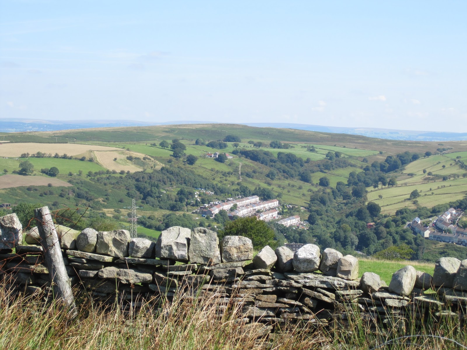
Retracing my steps to Cardiff Gate Retail Park, skirting the upmarket Cefn Mably estate, the River Rhymney appeared to be fuller than ever, with branches being swept along at a good speed, and the base of trees being covered. Floods seemed likely somewhere tonight.

Rhymney River

So were my waterproofs effective? Not entirely, my arms were wet as was the bottom of my trousers. My boots were wet but I had waded through a brook and several large and unexpectedly deep puddles. Gloves were soaked, but they were not designed to be waterproof, I do have waterproof gloves but once your hands get a little bit wet they are very difficult to pull on, my hands just will not slide past the lining.

A gpx file of the route I took can be obtained from wikiloc.com. The route is already on Viewranger thanks to Harri Roberts.

Sunday 23 October 2016

Caerphilly to Cardiff on Rhymney Valley Riverside Walk

Today I walked the second part of the 32 mile Rhymney Valley Riverside Walk, starting at Caerphilly Railway Station and finishing at Cardiff Gate bus stop. A mixed walk with some enjoyable sections along a disused railway line and a diversion to an early iron bridge, but also some unrewarding farmland, where little consideration was given to walkers.

I started at from the railway station in Caerphilly, home to a dramatic castle, and birth place of Tommy Cooper and Caerphilly cheese. No Caerphilly cheese is now made in the area, and Tommy Cooper moved out of the area when he was three to avoid the pollution. Such pollution has now long since gone with the demise of the coal mines.

Concrete wheel of Caerphilly Cheese
After walking down one of the busy, main streets I reached the Rhymney River and followed the path east along the river, leaving the traffic behind and joining morning dog walkers. A few asked me "how are you?", I am never quite sure how to answer: a discussion of how I don't feel as fit as I feel I should and/or a query after the other persons health? I usually just give a non-committal, polite greeting and walk on although this does not answer their question, if answer was needed. The tarmac path followed the grassy banks of the river with light industrial units opposite. On the far mountain the remains of the tips left by the nearby coal mine could be discerned, although now covered with grass. This section of walk is along the southern boundary of the South Wales Coalfield, and there are a few instructive signs describing the history.

Walking along the banks of the Rhymney river near Caerphilly

Entrance to path that takes you to Waterloo

The path eventually joined the road, but the point at which you then leave the road on the right is hard to spot. If you find it, the path leads you into the village of Waterloo, from which another path, also easy to miss, takes you along the route of an old abandoned railway line (with a diversion through a fields). This is part of the Machen Forge Trail with some interesting descriptions of lives gone by wrapped around posts. Leaving the old railway just before a stoutly built, stone viaduct, the route takes you into Machen (with some new houses being built on the site of the old coal mine, I wondered if they had obtained a survey from the Coal Authority).

After Machen the path goes through fields on the north side of the river. This was not always easy as some of the fields the path crossed had been ploughed over and the route of the path is difficult to locate. I briefly diverted off the Riverside Walk route to visit the Iron Bridge, built in 1829 and recently restored.

The Iron Bridge
The route continued through more fields with views of the river. Surprisingly, the river did not seemed to have grown much over the past 15 miles or so. After Michaelstone bridge things became difficult. The footpath, marked with a yellow arrow, went across a field of what might have been young cabbages. Crossing the field would have resulted in crop damage. Maybe I was entitled to damage the farmer's crop but this goes against the "Countryside Code" and good manners, so I walked along the road to rejoin the route at the next field. Although the map showed this crossed by more than one footpath, it had been ploughed, tilled and looked like it had been recently seeded.

Route of footpath

Eventually I reached the Moody Sow farm park and shop, judging by the number of cars and prams this was very popular with parents and young children. After crossing the road I was again faced with a problem. The leaflet and my map indicated a path across a field. There were no signs or styles, but a choice of gates. I was unsure where exactly the path was meant to go, so took a slightly longer route through the gates of Cefn Mably Private Estate (signs emphasised the word private, but a footpath sign gave me confidence to walk through the gates). Crossing more fields I reached the M4 motorway. The footpath takes you underneath, and then a short walk brings you to Llanederyn. This little village has a church of Norman foundation and a 15th century pub. A new housing development means the pub should have some additional customers shortly. This marks the end of the Rhymney Valley Riverside Walk, to catch a bus back into the centre of Cardiff you cross the busy roundabout to the Pontprennau bus stop just before the Cardiff Gate Retail development, where I rewarded myself with a Costa Coffee and muffin for completing the walk (the muffin slightly spoilt by some gooey stiff they put inside).

In all today's walk was 22.2 km long. A gpx file of the route can be downloaded from wikiloc at this link. For those using smartphones and tablets it is on Viewranger, short code johnpon0012. The Rhymney Valley Riverside Walk crossed several other walks today, the Machen Forge Trail, the Iron Bridge walk, the Michaelstone-y-Fedw Circular, the Rhymney Riverside Circular Walk and the Craig Diamond Jubilee path. I thought perhaps it may be better to have fewer walks, but waymark them properly and ensure they are maintained open.

To reach the estuary of the Rhymney valley I subsequently continued my walk along the Rhymney Trail through Cardiff, described here. Cardiff's Rhymney trail can also be reached by by following the path (rather muddy when I walked it in November) south along the river just before the last underpass that takes you to Llanederyn church.


Sunday 16 October 2016

Rhymney to Caerphilly on Rhymney Valley Riverside Walk

In my earlier posts I walked along the Rhymney Valley Ridgeway Walk ending up near the town of Rhymney itself. I was thinking of coming back down the bottom of the valley and thought I would have to make up the route itself.  However, although not marked on my Ordnance Survey map, I discovered that Caerphilly County Council, with support the EU's European Regional Development Fund, had created leaflets on a route called the Rhymney Valley Riverside Walk, which may be downloaded from the Internet.  This 32 mile route extends from Bute town, above Rhymney, to the outskirts of Cardiff. This post records my first day walking along the route from Rhymney to Caerphilly: a mixture of roads, disused railway tracks, farmland and reclaimed industrial areas, through urban areas of terraced housing and old chapels characteristic of the area and wooded parks and farmland.

I had already covered the walk from Bute town to Rhymney in my last post (during which I saw no signs indicating I was on the Rhymney Valley Riverside path) so I started at Rhymney railway station catching one of the hourly trains from Cardiff to what is the end of the line. As it was not marked on my Ordnance Explorer map (and I could find no "gpx" files on the Internet to download to my gps) I was relying on Caerphilly Council's leaflets to show me where I was meant to walk. This initially lead me onto a railway line, long since abandoned, that made a pleasant walk as the trees, starting to turn yellow with autumn arriving, hid the view of a busy road and some old industrial area. Then after a short stretch of road into Pontlottyn, the path went through playing fields, past a school, some ground with reptile proof fencing (to keep the newts in?) and then some farmer's fields. The route through the fields was not clear and an Explorer Ordnance Survey map is needed to make sure you keep to the footpath. On the other hand, a map does not always help as the Riverside Walk often takes paths that are not marked as rights of way on the map or on the ground (as in the route directly after Pontlottyn Railway station).

To keep newts from straying?

After some muddy fields I joined a tarmaced path that lead through what I took to be reclaimed sites of coal mines, now beautifully landscaped with young trees and used by local people walking their dogs. The River Rhymney gurgled beside the path, which lead into a street of terraced houses marking the start of New Tredegar.

Path through reclaimed industrial land on approach to New Tredegar

River Rhymney
After passing a few shops and an old chapel, like many in the area no longer used for worship, I reached the Winding House. There is no longer any coal mining in the area but the Winding House is a small museum complete with cafe and gift shop. The museum included remains from the Roman fort at Gelligaer that I visited on my previous post but my main interest was the history of the coal mine,  which closed in 1967. By far the biggest exhibit was the winding machine housed in the old winding house. This enormous steam powered winch, dating from the 19th century, lifted miners and coal to the surface. Maintained  by volunteers, it is still run on occasions although now powered by an electric motor. The coffee and fruit cake was also pretty good and the books on the miners' sufferings (including the 1984 strike) were worth a browse.

After New Tredegar I joined another disused railway line. These railways were built by different mine or dock owners to take the coal from the mines to the coast, such that there was often more than one railway up the same valley. Those no longer required for passenger traffic have been turned into excellent walks and bike paths, and being old railway lines do not have steep gradients.

Pedestrian bridge to Winding House built to look like a pithead, now no longer seen with the demise of coal mining in South Wales
The path continued through Bargoed Woodland park, another area reclaimed from the coal mining industry, now planted with young trees and with tarmaced paths and another interesting pedestrian bridge. I saw my first sign of any kind for the Rhymney Valley Riverside Walk on reaching Pengam, one of only two I came across on my day's walk. Typically it was defaced by graffiti. It is sad when the Council, Welsh government, EU and others put so much effort into making the Valleys beautiful that some people choose to despoil the environment. With the number of drinks cans I passed discarded by the path you could have restarted the metal industry.

Sign for Rhymney Valley Riverside Walk
After Pengam, navigation became more complicated, as the route skirted housing developments with paths not on my Ordnance Survey map, with sections along roads between. Finding the right road or path to follow was difficult, but I eventually reached the glorious Hengoed Viaduct which the path crosses. After a section of road walking at Ystrad Mynach the path crosses the river. The Council's leaflet implies that you then immediately walk along the riverside, however, short of abseiling down over the side of the bridge, this is not possible. Instead I reached the river by entering the industrial estate and then turning down the first road on the right. The river path is at the end of this road.

Following the complicated path between roads and riverside fields become increasingly difficult as it started to rain, gently at first and then heavily. I had printed out relevant maps of the route from the leaflets on the internet, and the rain threatened to turn them into a inky pulp. Nevertheless I believe I followed the correct path until I reached the outskirts of Caerphilly. Now rather wet it was time to navigate via the quickest route to Caerphilly railway station, where as luck would have it a train was just pulling in.

From Train Station to Train Station (and excluding wrong turns as I tried to work out where I was meant to go) the day's walk was 30.1 km. It was generally flat and overall you are loosing height as you go down the valley. You pass close by a number of railway stations (at Hengoed, Pontlottyn etc.) so it is easy to make the walk longer or shorter as required. A gpx file of the route can be downloaded from the wikiloc site. The route is also on ViewRanger short code johnpon0010.

Monday 10 October 2016

Hengoed to Rhymney on Rhymney Valley Ridgeway Walk

My Ordnance Survey Explorer maps show that the Rhynmey Valley Ridgeway Walk has a section from near Hengoed to Rhymney. I followed the route marked on the map, from railway station to railway station, but apart from one waymark, I found no signs on the ground indicating where the Ridgeway walk was intended to go. Based on the map it goes north following the ridges on the west side of the Rhymney valley, and is a mixture of pastoral farmland and open moors with some interesting historic remains.

I started at Hengoed railway station and initially followed the same route through Penallta Country park that I followed in my "Hengoed to Cefn Onn" post, passing men enjoying their Saturday morning fishing in the small lakes in the park, with the surrounding silver birch leaves gradually turning yellow. Difficult to imagine that it is actually an old coal tip. After the park I turned north by the bridge across the railway line. The map showed the footpath heading over marshy fields, although I could see little or no sign of a path in the fields. After these fields the route briefly goes through part of Penallta park before more fields. The typical yellow arrows showing where a footpath goes were missing, damaged or else destroyed. One might imagine that the farmer disliked a footpath crossing his fields however, the lack of direction indicators just means that people like me wander around their land searching for the correct route, a job made more difficult as some of the field boundaries shown on the map are no longer there, and new fences have been added.

Damaged direction indicators including one of the only Rhymney Ridgeway signs on this section
Carefully trying to follow the map around the back of some houses I reached Gelligaer, where I rewarded myself with a very nice pork pie from one of the shops (trying to convince myself that my walking would burn up the excess calories). On another occasion I would probably take a different route, either that given for this path in the Cicerone book "Walking in the South Wales Valleys", or there must be some way up through Penallta Country Park.

The path goes through the graveyard beside Gelligaer church (from where I heard the sounds of organ music) and then follows the waymarked "Roman Walk" which takes you past what are reported as extensive Roman remains. Sadly only some uneven ground and humps are now visible of the fort, bathhouse, granaries and other archaeology, which were excavated back in 1900.

After crossing further fields you reach Gelligaer common, where (after passing two dead sheep) I went from track to track keeping on the right hand side of the stream as shown on the map until I reached the next road section. The map shows more Roman remains but they are difficult to spot, and I missed the Celtic cross marking the site of Capel Gwladys that I visited on a previous occasion.

After this section of moor, a good path takes you down into a pretty, steep-sided, wooded valley and up to some houses with a community area, with benches and a hut, tucked in behind. Climbing up out of the valley there are more fields as you cross into a new valley. If you look carefully you can see a grassed over slag heap on the other side of the valley, more remains of the old coal mining industry. Eventually you cross another stream and reach a gravel road along the ridge. This brings you to the atmospheric Capel Birthdir. There is a graveyard, recording the lives of the long deceased, the remains of the chapel and a replica of the Celtic cross that was found here. Shortly after is another replica, of Tegernacus' stone (he was son of Martius') which commemorates his death. The original, which dates from the seventh century or earlier, is held elsewhere for safe keeping.

Capel Birthdir replica Celtic cross
The road continues along the ridge across open moors, rough ground with rushes, populated with sheep and cows, which have an empty beauty. There are distant views to far off mountains and the occasional peaceful looking village. Sadly there are those who seek to destroy this beauty, dumping fridges, old toys, plasterboard and empty beer cans beside the track, too lazy or stupid to dispose of their rubbish in its rightful place. Beside the track is a strange, metal structure which is the Brecon DVOR. This is a beacon that emits VHF signals that aeroplanes can use to work out where they should be going. More information here.

I continued along the ridge, the ground dropping into the Rhymney valley with its ribbon development of houses to the east. It seems a good spot for paragliders, with several circling around miraculously gaining height as the soared over the slope. At first I though they must have motors, but no, it was just the wind and the thermals.

Paragliders above Rhymney
The last section of the Rhymney ridgeway walk after the houses at Fochriw is across moorland with no particular path evident. At first you just have to struggle across rushes and muddy patches following occasional tracks and sheep paths in a NNW direction. However after crossing a stream the presence of fences makes it difficult to determine where best to go. This is my second time of trying to follow the route marked on the map and again I had to divert and drop down to the road by an industrial estate to avoid the risk of being forced to climb over barbed wire. This meant the remaining few kilometres to Bute town were along a road, fortunately with a pavement. On another occasion I might be tempted to miss out this section, unmarked by any arrows or signs, and head down to Pontlottyn railway station from Fochriw.

Bute town is an interesting "model village" built by the manager of the ironworks that used to be in Rhymney in the early 19th centuary. From Bute town there is a pleasant walk by a small river that takes you down to Rhymney railway station.

Bute town

Walk back to Rhymney
My walk was 25 kilometres long, with a total ascent of 447 metres. A gpx file of the trail can be found on wikilocs and also on Viewranger, code johnpon0009.

Tuesday 16 August 2016

Hengoed to Cefn-Onn on Rhymney Valley Ridgeway Walk

Having previously walked from Cefn-Onn park on the north side of Cardiff to Hengoed railway station on the eastern arm of the Rhymney Valley Ridgeway, today I returned to Cefn-Onn by the western arm of this circular walk. Leaflets on the route can be found here and here.

This first part of the route follows an old railway line (climb up to the old railway line from the current railway station rather than going along the road). A short distance along this abandoned line, there was a low metal bar across the path to prevent motorised vehicles. Possibly inspired by the Olympic gymnasts that I had been watching the night before I attempted to jump across it. The result was I went flying, causing a nearby man to ask if I was OK. Apart from a graze on my leg, only my pride was hurt.

The old railway line took me into Penallta Country park, once a coal mining site and now a pleasant, area of lakes, birch & beech trees and dog walkers. On leaving the park, the route turns south across the main road into fields. After some pylons the Ordnance survey map said to turn right along the field boundary, which I did but failed to find an exit out if the field. The owner of the field drove up and ask me what I was doing. On explaining she pointed out the correct exit onto a farm track, which was waymarked but not quite as marked on the map. The gps trail in the link below shows the correct route.

Entrance to Penallta Country park, following path of abandoned railway

After walking along some narrow roads (passed an attractive looking Inn) the path rose onto moorland. This area of South Wales typically consists of houses (often terraced) in the valleys, farmland on the lower slopes of the hills and moorland on the top of the ridges. In places (especially steeper slopes) trees replace the farm and moorland. There were Welsh ponies and their foals among the bracken and rushes, they seemed undecided whether to back away from me or follow me. As I walked I scattered small birds from the undergrowth and overhead some bird of prey was gliding in lazy loops over the sunny hillside.

Typical South Wales country side, terraced houses, farmland and moors

A section of road followed with an old church (open so you could have a look inside unlike many these days) with gravestones dating from the 19th centuary. Then it was another section of moor around Mynydd Meio. When I last walked this section, I had to give up due to impassable mud, fortunately it was now August and the mud had largely dried up apart from a short section with convenient pieces of wood to balance on as you crossed more squidgy ground.

Approaching the outskirts of Caerphilly (passed another good looking pub) I was told off for walking on a private drive. There were no signs to indicate it was private, waymarking was ambiguous and a stile had disappeared apart from two stumps, so where I was meant to cross looked like a fence laced with electric fence wire. Two separate people admonished me so I headed over the fence and in the (correct) direction they pointed out. On the map the path then appears to follow the main road, but in reality a section of older road beside it made for a leafy stroll up towards the hill of Twyn Garwa. While August is kind to the walker in drying out pools of mud, it is less kind in that brambles are at their most extensive, and the path I took around the hill, which I believe is the correct one, meant pushing through bracken and brambles that pulled at my clothes (long trousers are a help here as well as avoiding the potential embarrassment of looking like a middle aged man in shorts). An alternative route closer to the summit of the Twyn Garwa, following a path used by horses, would have been less damaging.

Moorland with horses

I had promised myself some refreshment for all my efforts so I diverted to the "Mountain Snack bar" for a well earned ice cream. This also rewards you with some excellent views across the River Severn. Then I retraced my steps to the official path which after a pleasant walk through trees crosses a golf course. Golf courses always cause some difficulties when public footpaths cross them. There is a risk of having red faced men shouting "fore" at you on crossing the greens and I often find it unclear where I am actually meant to go. This golf course is better than many with a few waymarks, but a few more would be useful as I cannot be sure I followed the correct routing.

After crossing the main road, there is a final section of ridge and an old limestone quarry, before it was time to head down the ridge to Cefn-Onn park and beyond that the Lisvane and Thornhill railways station (on station serving two suburbs). On the way to Cefn-Onn look out for the ventilation shafts, used to help dig the railway tunnel under the ridge to Caerphilly.

Ventilation shaft above railways tunnel


In all the path was 27 kilometres long and a good days walk with a total ascent of 637m. The gps trail of the route can be found here.

Tuesday 2 August 2016

Cefn-Onn to Hengoed on Rhymney Valley Ridgeway Walk

There are a number of waymarked trails associated with the Rhymney Valley including the Rhymney Valley Ridgeway Walk and the Rhymney River Circular Walk. Today, and for the following few blogs, I will be walking the Rhymney Valley Ridgeway Walk, this consists of a circular, waymarked walk between Hengoed and Cardiff, and a section marked on the Ordnance Survey Map but not waymarked that goes from Hengoed to Rhymney. Leaflets on today's section are here and here.
I started from the Lisvane and Thornhill railway station, and walked up through Cefn Onn park, a beautiful area of trees and, in season, rhododendrons, where people walk their dogs. Today though it was raining, and so sitting on a bench I put on my water proof trousers etc.. This meant that the following walk up to the top of the ridge was rather sweaty in the August temperatures, resulting in more water inside of my water proofs than outside. I was glad to take them off as the rain eased off at the top, while looking at the view across Cardiff, although the sheep were taking to chances staying sheltered beneath trailers and trees.
Sheep Sheltering from rain

Waymarking

After a field of sheep and a farm offering eggs, the path went through beech woodland, which helped protect me from the rain that restarted. I took a short diversion to remind myself of the "secret" bunker left from the second world war for a "stay behind" resistance unit in case of German invasion. Then a walk down from one ridge, and across a few fields to the next. Unfortunately an over-friendly horse tried hard to waylay me, seemingly determined to extract my lunch from my back pack. Then more trees as I walked through Coed Craig Rupera, after passing Rupera Castle, which is need of some repairs (see my previous blog on the Glamorgan Ridgeway which included this section).
On reaching Draethen, I put my waterproofs back on in the face of continuing rain, and took the path through some pines and then along a path which was so overgrown with brambles I was forced to turn back and divert along a quiet country road. Eventually this lead to the path into Machen, through a waterlogged and smelly section behind the sports field (a diversion through the sports field may have been wise). After Machen the path climbs steeply and I stopped on a bench in the trees to eat my lunchtime roll in the rain. However the view from Machen mountain, that came after lunch, made the walk worthwhile, with cities of Newport and Cardiff both visible beneath the clouds.

View of Flat Holm and Steep Holm from Machen Mountain


Heading North along ridge


There followed a lengthy section following the ridge northwards passed some slag heaps left by the now defunct coal industry, and now used by people on scrambling motor bikes. As it was a Monday I thought I would not see many motor bikes around, then two passed me loudly at speed, and later two more.
The final section is through fields on paths unsuitable for motor bikes and lead to the impressive Hengoed railway viaduct. Although the railway is no more, the viaduct is now a walking and bike path, with views down the valley from viewing platforms that allow you to see over the walls, and some interesting public art. It does however lead to the working railway station of Hengoed where I had but a short wait for my train back home.

The walk is about 25.6 km and as it goes up and down ridges there are several hundred metres of ascent. The gps file of the route I took is available here.